A View of the Pier

Jack Finn Collection
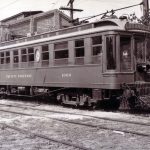
A view northward from the surfside Pacific Electric right-of-way in the Southern Division appears to show the Huntington Beach pier.
Jack Finn Collection
Recent Posts

Showing 8 comments
Jack Finn Collection
A view northward from the surfside Pacific Electric right-of-way in the Southern Division appears to show the Huntington Beach pier.
Jack Finn Collection
If that is Surfside in the foreground that would be the Seal Beach Pier in the distance and the southern Seal Beach breakwater in the foreground. Area on the immediate right is now Seal Beach US Navy facility. If the distant white smokestack is the Huntington Beach power station then the foreground is north Balboa Penninsula and the pier is Huntington.
Having lived in Surfside (60′-70’s) I would agree with your first assessment. The track curvitur to the right. and the break water south of Seal Beach.
The Huntington Beach Generating Station wasn’t built until the early 1950’s. There was an LA Gas & Electric power plant at Seal Beach near the present SCE and LADWP plants.
I didn’t realize that the track was that close to the ocean. Any closer and the interurban cars would have to be inspected by the Coast Guard.
A section of P.E. rail is still visible in the sands of Huntington Beach,at the ‘Dog Beach” section.
During winter months buses would replace transets at North Long Beach. They would need to operate through Garden Grove as these homes and PCH would [and still do]flood during extream high tides and storms from the south.
The is definitely looking west at the Seal Beach pier and the Seal Beach Steam Plant. This line was double tracked to Huntington Beach until 1941 and single track to Newport Beach. This photo was taken before the double track was taken out and the Seal Beach Naval Weapons Station was built which was in 1942. I collected things from the power plant before its demolition in 1967 and I know what it looked like from any angle.
Somebody mentioned that the line was double tracked to Huntington until the early forties but I see pictures in the late 30s where it is single track between Sunset and Huntington Beach
As Greg noted this is most likely looking west at the Seal Beach Pier, but that is NOT Surfside in the foreground because it was located on the ocean (left) side of the tracks). We are seeing the rear of homes in East Seal Beach which was located on the right, between the tracks and the Anaheim Bay inlet until they were evicted in 1944 when the Navy came in to build the Weapons Station. Other key identifiers are the disappearing tracks where they bend to the right to cross Anaheim Bay and follow the Electric Avenue right of way in SB, and the white Phillip C. Norton apartments in front (built around 1941) and the shorter post-1933 Earthquake smoke stack of the Water and Power plant in the background.