
Steve Griffis: Subway Terminal Building and Hill Street Station
Why are they where they are, why are they the size they are and why does the building have an extension to 4th Street?
By Steve Griffis
Being a little obsessed with Los Angeles’s original rail mass transit (before Metro), I have long thought about constructing a model of a portion of it. Oh, sure, I’d love to recreate the whole thing but I’m not that delusional yet.
The Pacific Electric Railway stretched from Canoga Park in the west to Redlands in the east. From Mt Lowe way up in the mountains north of Los Angeles to Balboa in the South. In its time the Pacific Electric was the largest electric railway system in the world. It connected all the major cities surrounding Los Angeles.
The Los Angeles Railway covered what is now called the core of Los Angeles. From almost Hancock Park in the west to Huntington Park in the east. From Eagle Rock in the north to Inglewood in the south. The Los Angeles Railway was enormous.
When I began seriously thinking of constructing a portion of the Pacific Electric and Los Angeles Railway, Hill Street in downtown Los Angeles immediately came to mind as a place to start. Pacific Electric and Los Angeles Railway both operated on Hill Street. There were two incline railways climbing Bunker Hill and two tunnels.
But the main feature of interest on Hill Street was the Hill Street Station. Interurban cars left from the Hill Street Station to Hollywood, the San Fernando Valley, Beverly Hills, Culver City and every beach city from Santa Monica to Redondo.
And with increasing auto congestion, a subway was built from the Hill Street Station property to west of downtown to lessen automobile impact on interurban cars to Hollywood and the San Fernando Valley. The Hill Street Station property and surrounding properties were reorganized to make room for a Subway Terminal Building and new integrated Hill Street Station.
Back to my goal of wanting to recreate a portion of the Pacific Electric and Los Angeles Railway. The Subway Terminal Building and Hill Street Station seemed like a challenge and so I would there to first draw the important features in CAD (Computer Aided Design). To do so I needed measurements. I wanted exact measurements. Or as close as I could get. I hate estimating.
I found some dimensions for the Subway Terminal Building on erha.org, 141’ by 330’. Why 141’? I was curious. I would have expected a multiple of 5 or 10. And what about the Subway Terminal Building Wing that extends to 4th St? Nothing I could find.
Then I discovered the architect’s description of the Subway Terminal Building. The Subway Terminal Building is 140’ 8.5” wide on Hill Street and 324’ from Hill Street to Olive St. The Subway Terminal Building has a wing along one side that is 121’ 11” long and 45’ wide (the wing contains the building’s mechanical equipment which I’ll bet wouldn’t fit in the main building). I know the new Hill Street Station is 100’ wide, obtained from the Interurban Specials on the Pacific Electric.
Okay, why these particular dimensions? And then I discovered “Baist’s Real Estate Atlas of Surveys of Los Angeles, 1921.” It’s amazing! Page after page of maps of Los Angeles of the time showing every street, their widths, the sewer lines, fire hydrant locations and most importantly, the dimensions of every lot on every block and buildings on those lots! And it’s all color coded!
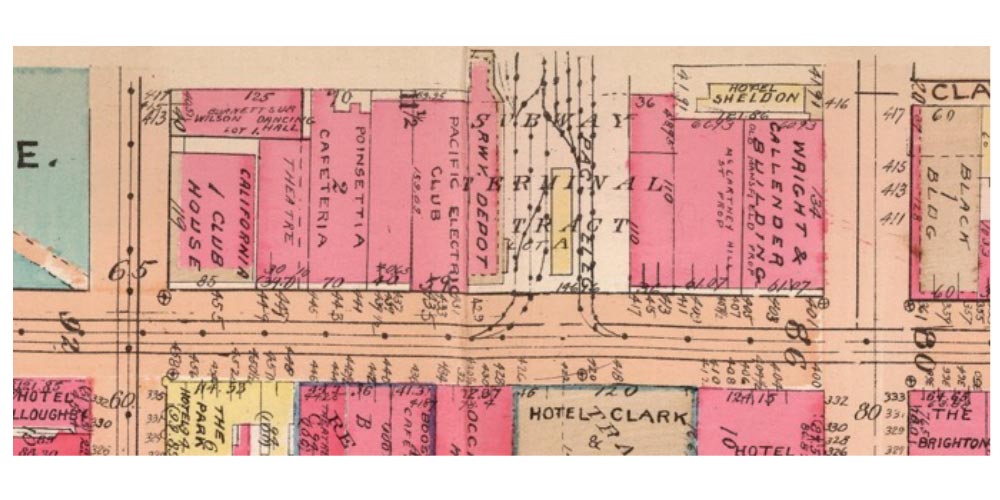
The block which contained the Hill Street Station prior to the subway is shown unfortunately split across two different pages in the Atlas. Because Atlas pages are not drawn exactly to scale I can’t easily join them together. So the Hill Street Station block is shown as an upper half and a lower half.
The block is bounded by Olive Street on the top, 5th Street on the left, 4th Street on the right, and Hill Street on the bottom. The Hill Street Station is down the middle of the block. Railway tracks are lines with dots on them.
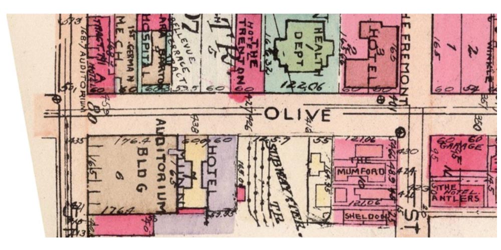
A vintage map of Olive Street in Los Angeles
A vintage map showing the Subway Terminal Building in Los Angeles
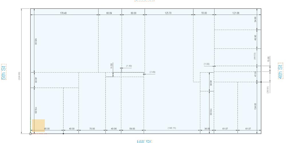
When I entered the individual lot dimensions into my CAD package I got the drawing below. As a note, I don’t know how surveyors did measurements back in 1921 but some lot boundaries just don’t line up perfectly. For instance, consider the 60’ lot on Olive St and the 59’ lot on Hill Street, surely the left and right boundaries must have actually lined up. The 55’ lot on Olive St and the 36’ lot on Hill Street is even worse. The big open area in the middle of the block is where the original Hill Street Station was located. From pictures of the Station, its boundary sure looks rectangular. So for the purposes of arguing how the Subway Terminal Building and Hill Street Station got their dimensions, I believe certain lot measurements are close enough.
If we add the 60’, 125.7’ and 55’ lots on Olive Street together we get 240.7’. Subtracting 100’ for the new Hill Street Station leaves 140.7’ for the Subway Terminal Building. Which is exactly 140’ 8.5”, the architect’s stated width. The length is exactly 324’ which also matches.
The Subway Terminal Building’s Wing, I believe is right where the 44.53’ lot on 4th St is located. The width is almost perfect, as is the length. My conclusion is that the Hotel Munn, the Pacific Electric Club and other buildings were torn down to make space for the Subway Terminal Building and new Hill Street Station. This must have been quite an undertaking for 1925.
I now had dimensions I felt were correct and when I finally build the Subway Terminal Building and Hill Street Station it’s as close as I can come to recreating the real thing as it was.
A vintage map showing the Subway Terminal Building in Los Angeles


Can you explain the meaning of the lines and dotted lines on the street? Do the lines designate rails and catenary? They appear not to be to scale.
I’m sorry I think I figured this out. Do the outer lines represent the edge of the street and dotted lines represent centerline of trackage?
The dotted lines indicate that there is a rail line or lines in the street. There is no intent to show detail. The solid lines mark property boundaries. I believe I found that street widths include the sidewalks.
There were tracks under the paving on 5th between Olive and Grand as late as 2005 – they were removed to put in a new phone vault. It was fun watching them being removed with a front-end loader.